By Richard G. Biever
“What’s the difference between wonder and wander?” pondered Phil Anderson rhetorically.
It begins with a subtle — yet internally rapturous — “oooh” and “aaah.”
“It’s just a letter,” he said. “Wonder and wander go hand-in-hand. Why do you wander? It’s because you wonder. Curiosity … wonder: It’s what makes you get off the highway.”
Phil Anderson.
Off the highway, but on the back roads, is where Anderson has spent much of his life. At 61, the Carmel resident may be the only person to ever visit every Indiana city, town, hamlet, burg and wide spot in the road — all 2,230 of them.
Over the past 40 years, he made it his goal … then a mission … to underline each visited “place” shown in his atlas of Indiana counties until every named place in all 92 counties was underlined. His traveling was completed in November 2016 — as he and his wife, Beth, who often accompanied him on his journeys, visited the last unmarked place, Friendship in Ripley County.
Anderson now hopes to connect all the information, history, geography and culture he gleaned in his journeys into various media that others will find interesting and useful. He hopes to inspire others to pursue the wonder of wandering in their own ways. He’s already begun a website that brings his blog together with others’ travels.
He’s also slowly been assembling a book, probably still a few years from publication. While he’s not sure what it will be, he knows what it won’t be. It’s not going to be merely a travelogue — notes and thoughts about starting at point 0 and traveling to point 2,230. That’s not how he traveled.
Anderson’s wandering was done through hundreds, if not thousands, of visits and day trips first conducted as an FFA officer, then as a salesman into rural Indiana, and then as planned out weekend excursions with Beth.
One thing it will be is a memoir of his travels with her.
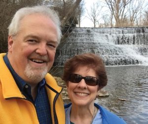
Beth Anderson indulged him in his wandering and served as navigator on many trips. An accomplished writer and corporate communicator, she helped plan and document the journeys. After first being diagnosed with skin cancer in early 2019, Beth died at age 59 in August 2019 from a rare complication from the medical treatment she was receiving. Her illness and passing detoured the project. But now Anderson is finding joy in revisiting the memories they shared of their journeys.
“She always enjoyed getting out there,” he said. “She was a wonderful wandering partner. She would be the one who would say just as soon as we got out of town, ‘Surely we’re not gonna stay on the highway.’ And, so, the book and website, everything is called ‘Life Off the Highway.’”
Beginnings

Back in the 1980s, before states began offering a myriad of personal and specialty license plates, Indiana’s standard plate bore the word “WANDER” in red letters at the top and “INDIANA” in white across a spring green bar at the bottom. At the time, the state’s tourism campaign was “Wander Indiana.”
The plate was ridiculed by many Hoosiers. The red letters stood out much more than the white, making people wonder if Hoosiers were from the state of Wander.
Anderson said he always liked the plate. Being in a state of Wander, or wonder, is a good thing, he reasoned. Its arrival on bumpers came just as he began rolling his odometer with many wandering miles as an agricultural supplies salesman after graduating from Purdue University.
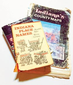
Anderson grew up on a farm near Frankfort. His parents always encouraged his curiosity, giving him a book on Indiana place names that sparked his interest in Indiana geography. Sunday afternoons often included a long drive with his dad under the pretense of looking at crops. The drives meandered around, never backtracking. “He taught me to drive one way to a destination and then another route on the return trip.”
and other items for his journeys.
Anderson’s first real taste of wandering the state came when he served as an Indiana FFA officer in 1979-80 while at Purdue. During the year, he and six fellow officers traveled over 100,000 miles visiting local school chapters, media outlets, agribusinesses, and program partners throughout Indiana.
“The way we did that, I refer to now as ‘looping.’” He’d plan his routes to visit several chapters on each trip, creating a loop from start to finish, not retracing his path. Also in college, he had a job with a seed company covering several counties in western Indiana. “I’m driving all over putting up plots, field signs, delivering soybeans. And I mean, this is rural. I didn’t deliver that stuff in town.”
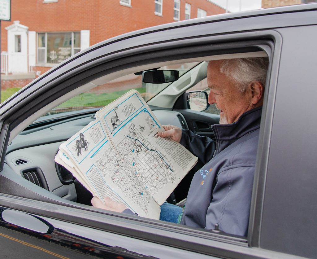
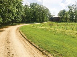
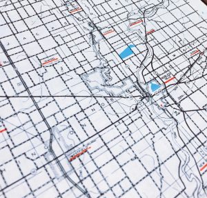
After college, he took a job as a fertilizer salesman in southeastern Indiana and learned that roads are not always flat or straight as they were in Frankfort or in western Indiana. To help him make his sales visits, his boss suggested he purchase a county-by-county road atlas to help him find the back-road connections between clients. This became his early “GPS” revealing every paved and unpaved road in every county. Some of the roads, he would discover, seemed to have existed only on the map; they weren’t there when he tried to drive them.
As he traveled his territory, he would drive through small towns and hamlets. He also began collecting books and old maps that told of Indiana’s place names, history, and natural spaces. He started to visit many of the dots in the atlas wondering which spots might be interesting.
“I’m looking at this map. And I’ve got customers that are here … and over here,” he noted with his finger. “So, I would make it a point: Take that road. Go there. See what’s out there.”
Journeys
With his tattered atlas as the official guide, he had started marking all the places where he had been. By the mid-1990s, he realized just how many places he’d been to and how many more were left. That’s when he decided he should just explore them all. “So that became a mission,” he said.
“We’d go through and mark and mark and mark and mark. I have spreadsheets. I knew what I’d been to, what I hadn’t been to,” Anderson explained. “In the beginning, it was just doing sales work and ‘I wonder what that town is? I don’t know. I’ll go through it.’ So, it was accidental for 15-18-20 years. And then all of a sudden, I decided to go crazy.”
Despite changing careers over the decades, he never veered far from rural and small town Indiana. He would serve as chief staff officer for four non-profits in agriculture and rural community development and finally as a private consultant — helping organizations and communities “connect the dots” strategically in their thinking. All of these experiences continued taking him off the highways. Beth also began traveling with him on a number of weekend trips. They’d stay at bed and breakfasts, visit antique shops and crisscross the counties.
“I’ve seen beautiful valleys, stark prairies, and rivers, hills, and streams,” he blogged about his journeys. “I have visited parks, antique stores, wineries, stayed at local inns, eaten at restaurants, seen historic buildings and markers, and so much more.”
He became fascinated by the state’s varied topography and history and how county roads connected to them. In the flatlands, the roads generally run true east-west, north-south. In the south-central Hoosier uplands where the glaciers stopped and along the Ohio River, roads seem to have no visual rhyme or reason, following the crazy contours of the land. Then in Knox and Clark counties, Indiana’s two oldest counties, the roads are gridded on a diagonal following French geographical survey methods.
On one trip, he found an old map showing all the railroads. It answered his wondering why some towns in the middle of nowhere seemed aligned with others on a straight line or arc. It’s because they had been on a “line.” “Oh, that’s why those towns are there … that’s where the railroads went.”
He also began learning not to trust his map when it came to some places. “I’ve learned that some of them just don’t exist. They’re on the map. They’re in the atlas, but they don’t exist. So I have pictures of Martin [in northwest Vanderburgh County]. You can see where the railroad went across the road, but there’s nothing there. And we went up to finish Porter County. We had eight places left. We found four.”
Traveling off the highways certainly made his journeys longer, often doubling and tripling the drive time. And coming up empty trying to find a destination no longer there might make some folks scratch their heads and scoff about the waste of time and gas. But here’s the thing, Anderson underscored: “The journey is more important than the destination.”
That’s especially true when the destination turned out to no longer exist.
In the journey to one spot, he would pass through a half dozen others. In a little town or crossroad, he’d get to wondering about an old substantial three-story structure, still standing but obviously long deserted. He’d figure out what it was by reading the cryptic placement of screws left behind that once held the letters on the building’s facade. Or he’ll wonder about the series of old ornamental concrete posts, standing like sentries, along county roads. Things he’d see, or couldn’t find, would spark more questions than he had when he had left home. “I’m curious: What makes it a place; and then what makes it stop being a place?”
When Beth was able to join him, the destination became even less significant. “In many cases, they’re just dots on the map, but my memories are so much more. It was about the journey. In that journey, we learned about us.”
And, he said, sometimes, out in the rural places, they discovered much more than what was ever shown on any map. “We were very active in our church. But my mother, especially, had taught me that God is in everything around us. So, I could feel in touch with God sometimes better on a back road than in the church pew.
“There are times when we were out there, we’d find a sunset. You come over a crest and go, ‘Wow! This is what God’s creation’s about … amazing feelings of being in God’s presence. And if I find it now, then I find that moment with Beth.”
Friendship
On Nov. 19, 2016, Phil and Beth reached the final destination: Friendship. The unincorporated town, famous for its national muzzle loading competitions, sits at the hub of a junction of five counties: Ripley, Dearborn, Ohio, Switzerland and Jefferson. It’s in the area where he began his first job and bought the atlas, but he had never gone there.

In mid-2015, he had 133 places to go spread over 31 counties. That’s when they decided to meticulously plan out the final road trips. They were intentional in choosing Friendship as the last stop. “Southeastern Indiana is where Indiana began,” he said. “What a good place to finish.”
As they drove into Friendship that evening, Beth turned to Phil and asked, “How do you feel? This has been a long time — 37 years — and you’re done. How do you feel about that?”
Thinking for a second and with a bit of relief, he said, “I don’t have to go back to any place I don’t want to go.”
She then pulled out two signs he didn’t know she made and had with her. One said, “You made it!” with “#2,230” and the date. She took a picture of him holding the sign. “That’s not the one I like,” he said.
The other sign said, “We did it!” That’s the one he loves. “Did she go to all those places with me? No, but if it wasn’t for her, I wouldn’t have gotten to all. That was powerful. That was her attention to detail, pulling that out.”
Connecting Dots
Indiana county road atlas, he began
underlining them. It then became
a mission to visit and underline them all.
Photo courtesy of Phil Anderson.
While he’s connected dots of how topography, natural resources, history and culture all interconnect to those place names on the map, no “big picture” of Indiana emerged from his wanderings. The lines, he explained, kept getting smudged behind him. “When you think about connecting the dots, is it a complete picture? No, because it continues to evolve.
“In the time that I traveled, that 37-year- now 40-year-window, there have been high schools that have disappeared and appeared. There have been railroads that have disappeared, and rails-to-trails have emerged. Towns have disappeared, and others have emerged. In 1980, Fishers had 2,000 people; today, it’s over 99,000. Meanwhile, Gary was 151,000, and now it’s 80,000. Manufacturing comes and goes. GM left places; Toyota showed up; Honda showed up. So, it’s never a complete picture.”
But a fuller life for himself emerged from his wanderings. His insatiable curiosity about little things most people see and take for granted were stirred and answered, and he has beautiful memories of long hours spent alone with Beth. He recalled just the two of them navigating countless gravel and dirt roads and talking. He recalled specific picnic lunches: one at a park in Redkey; the other while sitting on their cooler inside the Medora covered bridge. A summer cloudburst had them seek shelter beneath its cover. They ate, talked and listened to the rainfall.
“While I longed to do it, she loved that wandering spirit. She found it in her,” he said. “We were better because we traveled together. When you’re out there wandering around, it gives you a chance to talk. So, when we would do our bed and breakfasts, that was our chance away from the kids. We’d leave them with a relative. We’d go overnight wandering and picnicking. All those things that we got to do that was just us.
“That’s all I want is for people to find what they like and go enjoy it.”
Anderson said his journeys haven’t stopped since Beth’s passing. He is now sometimes joined by their two adult daughters and their husbands or other relatives. They will meet him at various places because he’s still taking his time taking the back roads and avoids the interstates. “So, I still wander, but it’s different. I went to places just to see what it was like [without her]. I learned something since she’s been gone: It didn’t matter where I was as long as we were together — which now puts wandering in a different frame.”
As he connected the 2,230 dots on the map, Anderson drew a bigger picture of Indiana. But more than that he drew a stronger connection to his wife. “You learn things about each other. It was time invested in each other,” he said. “And that’s why we wandered.”
RICHARD G. BIEVER is senior editor of Indiana Connection